GPS - protection of innocence
No,
it’s not a clerical error, it’s not about the presumption of innocence
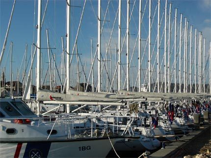
at all. The sad sensation of the last week, the capsizing of a sailboat
requiring a life during a race in the Adria, aroused the emotions.
Based on the asseveration of would-be experts the yellow press went
into speculations not even presuming the crew’s innocence, their fair
and professional behavior, dishonoring the memory of the yachtsman, who
lost his life in fighting a transhuman battle.
What
do we know? The participants sailed southward in strong wind but not in
extreme meteorological conditions toward the target set in front of
Vodice, a well-known port of the Central Adrian area, when the leading
boat capsized abruptly and started to sink with mast down. The event
happened at about a quarter to 10 in the evening, the crew of six had
no chance at all to leave the boat in a professional and safe way and
to send distress signals on the radio. However, the fellow-racers
sailing nearby saw the disaster and the rescue got started immediately.
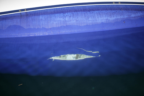
The capsizing happened due to the breaking-off of the keel. The absence
of this part not just caused the loss of stability but the huge gap on
the bottom of the body decided the fate of the boat.
The
rescue was not yet over, but there were people, who already “knew” that
the boat had been dashed against a rock and this caused the disaster.
The yellow press had already information about some drinks the crew had
taken and mad and madder speculations were born.
The examination of
the boats reaching the shore produced a breath-taking result. So
serious construction defects were detected on the products of the
famous German shipyard that all the sea-letters of the type were
withdrawn with an immediate effect. Of course, the examinations are not
yet completed and the engineers and lawyers have a great task to deal
with relating the question of responsibility. The fact that the quality
of the ships is below of any standard does not mean that the captain
may not be responsible. If it is true that the boat was dashed against
a rock, then the captain misconduced the boat and in this way he caused
the accident. How can he prove his innocence, if there are no traces
left on the sea and it is almost impossible to find the part, which
broke-off?
Of course, no use to search anything on the water, but
the event did not passed without any trace. The participating boats
were equipped with a tool, which periodically or on order (query) sent
the co-ordinates of the actual position and the chain of the positions
recorded in the memory, the so called track log. If it is so simple –
may we think – we have nothing else to do than simply read out the
position where the boat, which suffered the accident “stopped”. The
keel must be somewhere there, one must just raise it from the water and
examine it well. Unfortunately, the situation is not that simple. The
Omni Track equipment sank under the water in the capsized boat and the
sea water stopped the operation of the equipment in seconds, so it was
not able to transmit information anymore (presently experts try to
regain the data in laboratory conditions).
The situation however is
not hopeless. From the data sent from the other participating boats the
events can be quite well reconstructed. The tracks made are clearly
visible, the boats moving by sail and by engine can be separated easily
and the change in the rhythm after the capsizing is very spectacular.
From the testimonies we know which boat noticed the capsizing, they are
the ones to turn and go to the scene of the event first. The boat that
met with the accident sank immediately, there could be no considerable
drift from the location where the boat lost its keel. We also know that
3 boats picked up the surviving crew and we may assume that the teams
participating in the rescue did activate the MOB (Man Over Board)
function in their own navigation system. As the 3 boats picked up the
survivors in different times but practically (considering the constant
speed drift) from the same location the co-ordinates of this position
can be red out from the track logs.
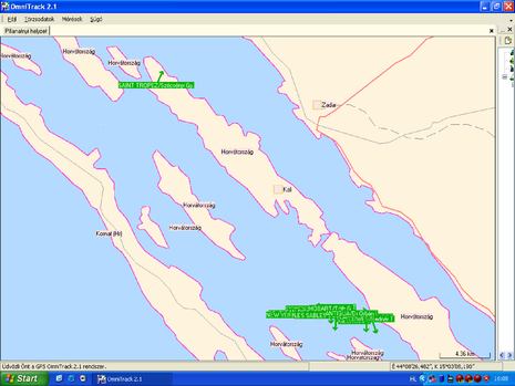
4 PM on the 25th of April.
The field, which is in race since the morning hours is cruising
south-easterly in the tube defined by Pasman and Kornat islands. The
strong near wind and the billows mean a serious, but not extreme
challenge both for the boats and the crews. The first serious technical
problems occur. We can see on the picture that the SAINT TROPEZ /
captain Gyula Szécsényi having a problem in the steering mechanism
makes a responsible decision: they give up the race and they are in
course to Zadar – Biograd. (The arrows show the direction of the boats.)
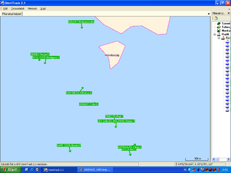
Let’s
blow up the field! We can see that 11 boats are still in the race, the
KIEL, which will meet the accident is in the leading group with captain
Zoltán Kirimi in command.
18.50. Before
darkness falls the field reduced to 10 boats leaves Pasman islands.
COWES with Tibor Bednár in command backs out and follows the CAPE TOWN
/ Géza Soponyai, who stood out for mast braces problems keeping the
track on the outer side of Murter island toward the target, Vodice.
In
the meantime Kirimi takes the lead being in close race with ANTIGUA
with Dr Orbán in command, who keeps his eyes on his opponent.
3
hours later the field makes its way toward the Southern corner of
Murter island, when on the assigned channel of the race the first
distress signals become audible. István Fodor, the dispatcher of the
GPS System Ltd. being in charge of operating the satellite positioning
systems records 6 boats in the vicinity of the accident at 10.20 in the evening. No data arriving from KIEL.
In
order to understand the events though, the track logs recording the
entire track of the boats give much more information. The courses are
practically chains of positions, so co-ordinate, direction, time and
speed value can be assigned to any point of the log. Based on that an
analysis can be made who was present in the area in question and even
we can make conclusions relating the activity of the participants
during the rescue operation.
We already mentioned that due to the Kirimi – Dr. Orbán duel the ANTIGUA immediately noticed the capsizing
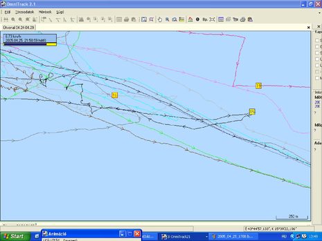
On
the picture below a longer period, the course of the events before and
after the capsizing can be seen. The position of the boat under
examination, the ANTIGUA with entry number 15, can be described at 21.51
by the co-ordinates indicated in the right bottom part of the screen.
This is the moment when they start the rescue by making a turn of 180
degrees. We can see that they go backward nearly one kilometer when
they reach the position of the accident. When they notice the problem
(it must be at 21.47, because
then they start the engine) probably they do not believe their eyes.
Surely, some shocked moments passes when they finally “make the
picture”, but the decision is fierce and exemplary.
Boat no. 19
has problems in the steering mechanism, therefore she cannot take part
in the rescue. Captain of boat no. 16 (TRIESTE) Tamás Perl is informed
about the events from the radio. He does not have to turn back, he
starts acting practically immediately.
When we check the track of TRIESTE separately we can see that at 22.11
the crew stops the engine during a very sophisticated maneuver. Two and
a half minutes later they restart the engine, it is obvious on the
lower chart when the generator revs reaching the required loading
level. During that period 3 survivors holding each other were lifted
into the boat! The motor had to be stopped so, that the propeller did
not cause even eventual an injury. On B 42 type ships the gear is in a
strange position, near to the floor and during lifting the people in
someone may kick it and move it out from the neutral gear. The captain
of the boat took measures with a respectable prudence.
The co-ordinate of the position: N 43º 45´ 02´´ E 015º 38´ 07´´
At 22.16 six boats traipse desperately, looking for the survivors and the capsized boat.
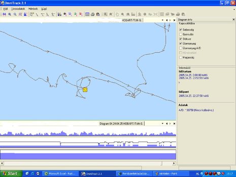
The dispatcher of the Omni Track system in Biograd sees the following screen at 22.20:
The next racer is found by captain Gábor Tóth (HOBART) at 22.28. The
analyzis of the track log shows well that heroic effort, which the
teams already tired from the all-day race make for rescuing their
friends. First they follow the racer swimming in the water from a
distance of 50 meters from windward, as they cannot know if the body of
the boat is not somewhere nearby. The first narrow loops show this
maneuver. Don’t forget, the orientation is difficult due to the dark
night, strong wind and large billows! The second bigger ∞ formation is
the track of two attempts, which ends up by picking up the lucky fellow
to the deck of the HOBART.
The co-ordinates are: N 43º 45´ 02´´ E 015º 37´ 57´´
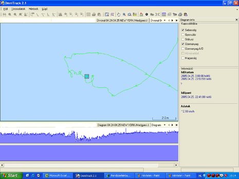
János
Medgyesi (NEW YORK) is an experienced captain, he is regularly
participating in the races in the Adria. In Mira Mare Cup he
participated with a relatively inexperienced crew, therefore he was not
in the leading group. After dark he decided to give up the race for his
crew’s safety and for keeping the good mood and to use the engine for
reaching the destination port. He started the engine at 21.10 and having received the distress signal he hurried to the scene. Not long after half past 11
he caught the sight of the capsized boat. Holding the rudder, which
stood vertically, the fifth survivor of the crew was clinging on, in a
shock. Almost one our had elapsed since the capsizing, the racer was
unable to co-operate, so János decided to clash to the damaged body by
his boat and he practically teared off the helpless sailor from the
rudder. Time: 22.41.
Co-ordinates: N 43º 45´ 05´´ E 015º 37´ 43´´´
If
we acknowledge that the drift (move over the sea bottom) of the boat
filled with water and the drift of the people may be considered more or
less linear then knowing the time of the capsizing and the times of the
rescue events we can determine the approximate position of the broken
keel. The total drift between the position of the accident and that of
the rescue is 850 meters. The damaged body of the boat made this
distance in practically one hour.
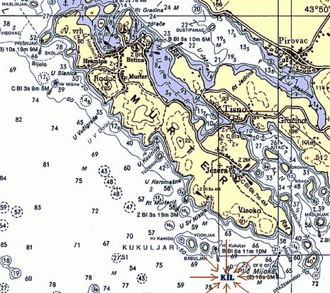
In my opinion the breaking-off of the keel must have happened somewhere in the vicinity of the point defined by co-ordinates N 43º 45´ 00´´ E 015º 38´ 19´´
within a circle with a radius of maximum 200 meter. This area is at
least eight hundred meters away from the Kukuljar Reef located below
Murter toward the open see, so we can practically exclude the
possibility, that the boat clashed to a rock.
In our article, of course, we only showed the screen shots made of the logs, so the Reader cannot “cross-examine” the pictures.
We
do not want either to encourage anybody to make efforts to raise the
keel of 2,5 tons from a depth of 60 m before or instead of the
investigating organizations. I think there is no need for that too.
But
we do want all those, who misled the public by their silly speculations
to understand that they can cause irremediable damages by their
irresponsible statements and the consequences may have a negative
impact in the future on the opinion about our fellow-countrymen sailing
in the Adria and also on the profitability of the businesses operating
with Hungarian capital.
I am sorry, that the people, who rescued lives were not interesting for the media. This article is about them and for them too.
András Gerő, Yacht Magazin Hungary
Fotók: www.sailing.hu, Yacht Magazin